Fishponds and the Hawaiian System of Ahupua‘a
The ancient Hawaiians have a strong spiritual relationship to the natural, physical environment [1,2]. Conservation and sustainability were crucial to their way of life as their island archipelago, situated in the center of the Pacific Ocean, is the most isolated population center on Earth [1,2]. The ancient Hawaiians developed a masterful plan to maximize land-use capacity for sustainability purposes. This involved dividing each island into subdivisions, called moku, which typically were wedge-shaped and extended from the mountains to the sea. Each moku was subdivided into smaller wedges called ahupua‘a, which also spanned from the mountaintop to the ocean, and the boundaries of which typically coincided with the footprint of a watershed [1,2]. As such, the ahupua‘a encompassed a “single natural drainage system” [2]. The ancient Hawaiians embraced the connection between the land and ocean, and maximized the fertility of this transitional region by building centers of aquaculture, the loko iʻa (fishponds), at the seaward terminus of the ahupua’a.

Fig. 1. He‘eia Fishpond is built atop the nearshore coral reef flat. The kuapa is seen as a thin line partitioning the fishpond from the reef flat. Photograph courtesy of the USGS High Resolution Orthoimagery for Honolulu, HI 2009
About He'eia Fishpond
Located on the windward side of O‘ahu in southern Kāne‘ohe Bay, and owned by Kamehameha Schools/Bishop Estate, He‘eia Fishpond (Fig. 1) is the second largest of at least 20 fishponds that once existed on the Kāne‘ohe Bay shoreline [3,4]. Estimated to be as much as 800 years old, He‘eia Fishpond supplied fish to the population residing in the He‘eia region [5]. The He‘eia Stream drainage basin spans an area of 9.324 square km, and the He‘eia watershed extends from the ocean to the ~0.86 km summit of the Ko‘olau Mountains ~5.1 km away [6].
He‘eia Fishpond is a loko kuapā [3,4] fishpond with a kuapā (wall) that completely encircles the pond [3,4]. Total fishpond area is ~0.356 square km; the circumference of the kuapā is ~2.5 km. The current size and shape of the pond has not changed since a survey done in 1913 [5]. He‘eia Fishpond receives freshwater from He‘eia Stream and saltwater from Kāneʻohe Bay through sluice gates (mākāhā). He‘eia stream bounds the northwest border of the pond and Kāne‘ohe Bay abuts the pond kuapā on the eastern side. A marsh upstream from the fishpond was traditionally planted with taro, using water diverted from He‘eia stream to irrigate the lōʻiīkalo (taro patch) [4]. Using stream water to flood the lōʻī had the added effect of trapping sediment eroded off the land, which reduced the sediment load arriving at the fishpond [3,5].
He‘eia Fishpond provides an exceptionally well-suited natural laboratory to conduct cutting-edge research on the linkage of watershed processes to coastal ocean ecosystem structure and functioning. This walled, 88-acre coastal pond adjacent to Kāne‘ohe Bay, O‘ahu, is situated at the land-sea boundary of the He‘eia watershed (ahupua‘a). Such fishponds were actively maintained and farmed by Hawaiians for centuries, and He‘eia Fishpond is currently in the midst of a renaissance under the stewardship of the non-profit organization Paepae O He‘eia, whose two main missions are, 1) to restore the pond to its non-impacted ecological state, and 2) to provide a science and Hawaiian cultural learning venue for K-12 students, and the broader community.
He‘eia Fishpond, estimated to be as much as 800 years old, is a loko kuapā type fishpond, meaning that it is a physically enclosed (walled) system in which timing and volume of stream and seawater input to the pond is controlled via sluice gates (mākāhā) in the wall (kuapā) (Apple and Kikuchi 1975, Henry 1993, Kikuchi 1976). These physical characteristics render He’eia Fishpond an ideal study site for physical-biogeochemical, land-ocean interface studies, as it permits the characterization of fluxes of water, sediment, nutrients and other dissolved and particulate materials in a quantitative manner not feasible for physically unbounded coastal ocean systems. From a research perspective, the pond functions essentially as a mesocosm embedded within the coastal ocean environment.

Table 1. Makaha dimensions
He'eia Fishpond Mākāhā
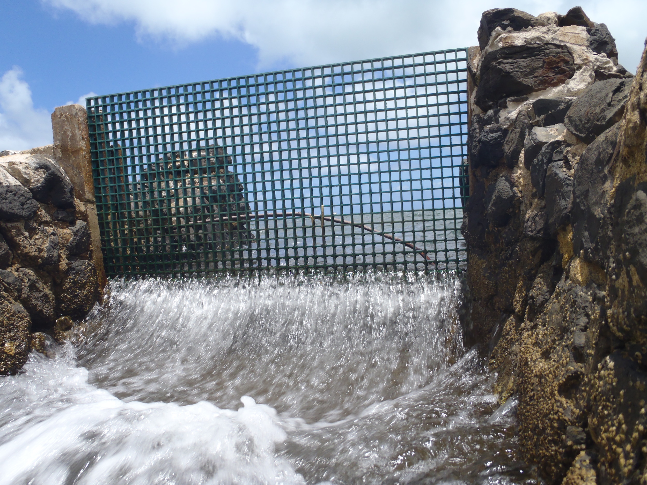
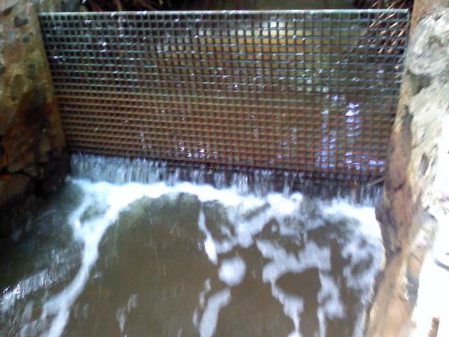
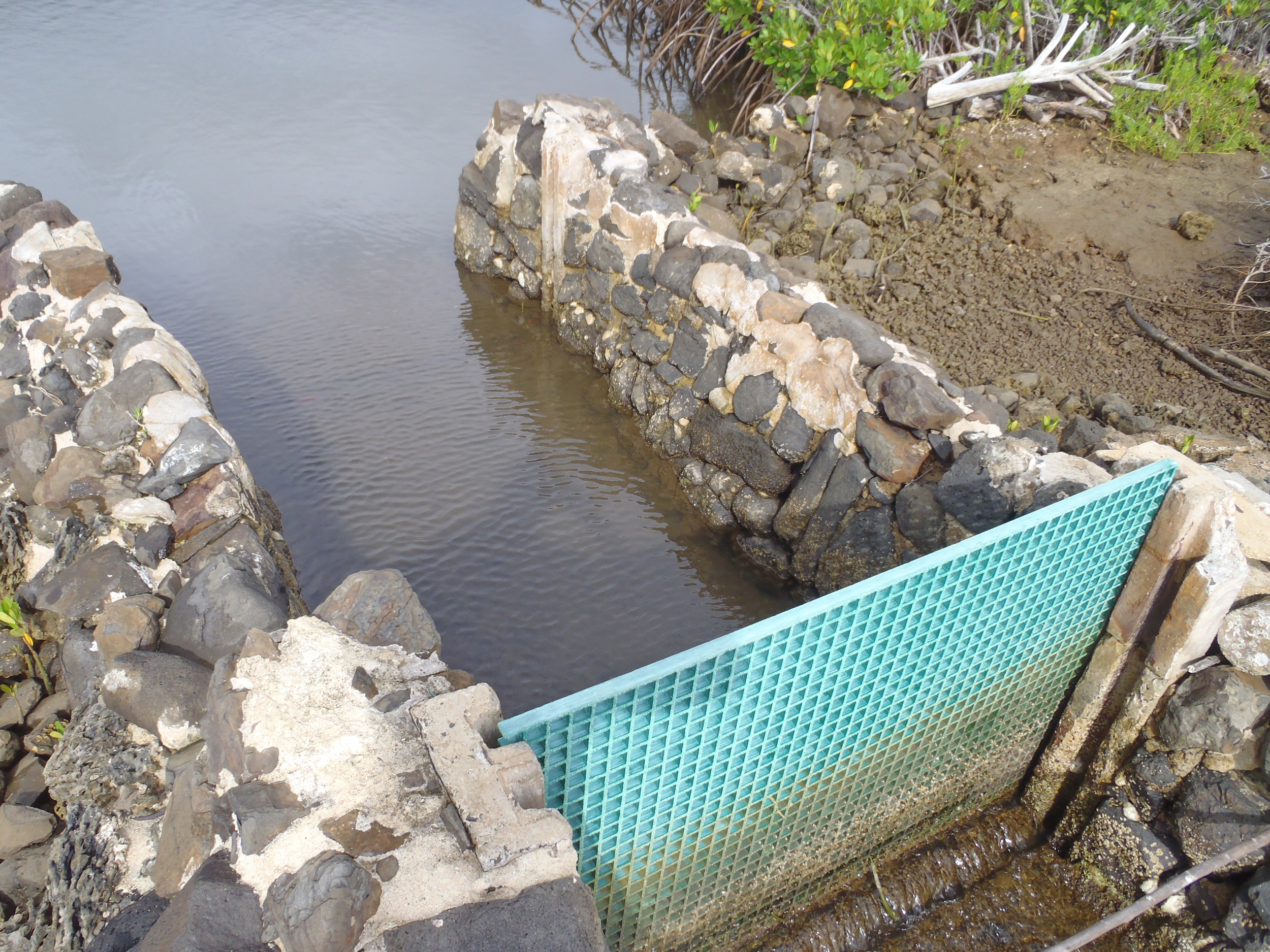
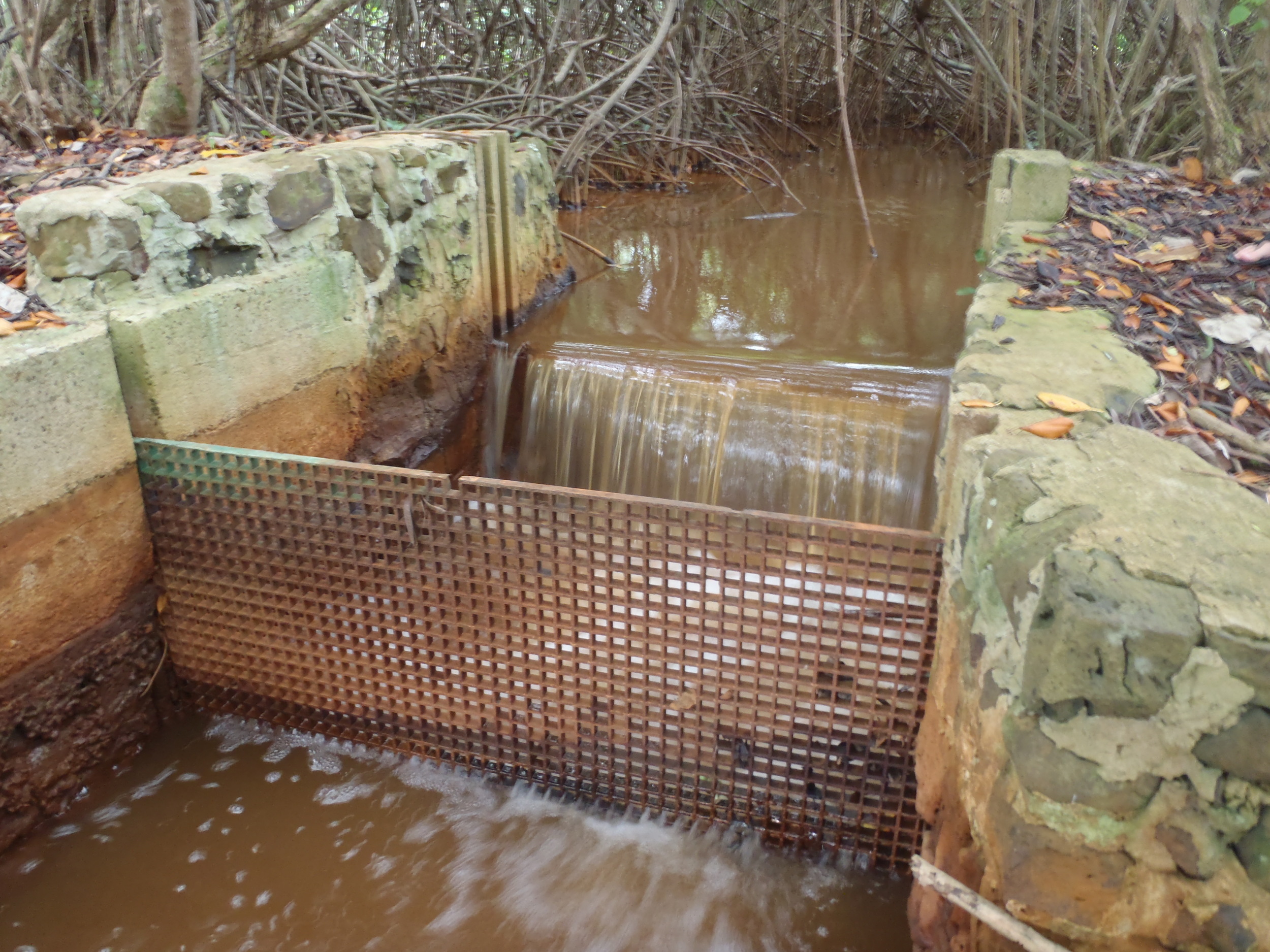
He‘eia fishpond has three freshwater mākāhā on its northwest boarder and five saltwater makaha along the east to southeast portion of the kuapā, for a total of 8 mākāhā. The freshwater makaha separate He‘eia Fishpond from He‘eia Stream. River Mākāhā 1 (RM1) is the northwestern most freshwater mākāhā and the first that He‘eia Stream encounters as it flow towards Kāne‘ohe Bay along the perimeter of the fishpond. RM1 is in a state of disrepair, such that there is diffuse surface flow; streamflow is not directed through a functional mākāhā at this site. River Mākāhā 2 (RM2) is the next downstream freshwater mākāhā , and River Makaha 3 (RM3) is the furthest downstream freshwater mākāhā , and is located nearest to the mouth of He‘eia Stream as it discharges into Kāne‘ohe Bay. Triple Makaha (TM) is the northernmost saltwater mākāhā and the nearest to the mouth of He‘eia Stream. TM is named such because there are three similarly sized makaha adjacent to one other. The largest mākāhā within the fishpond is Ocean Mākāhā 1 (OM1), which faces eastward toward Kāne‘ohe Bay. Ocean Mākāhā 2 (OM2) is the southernmost saltwater mākāhā and the furthest from the mouth of He‘eia Stream. The dimensions for the mākāhā are given in Table 1, with the exception of RM1, which is not intact.

Fig. 3 Ocean Break (OB)
Additional perimeter sampling sites
We have designated an additional opening in the kuapā as Ocean Break (OB). OB is a 50 m section of the wall that was destroyed during the Keapuka Flood of 1965 and, although repaired, was not rebuilt as high as the pre-existing wall such that water can exchange over top during high tide. Three additional perimeter locations that are routinely sampled include Ocean 1 (OCN1), located south of He‘eia Stream mouth, which is characterized by terrestrially-influenced seawater, and Ocean 2 (OCN2), the representative sample for Kāne‘ohe Bay surface water. Lastly, He‘eia Steam (Fig. 4) is also regularly sampled, and is referred to as the ‘River’ site.
![Fig. 4. He‘eia Fishpond pond-interior sampling grid, PVC stake locations and numbers [7].](https://images.squarespace-cdn.com/content/v1/51e5af9ee4b0dbb11fbe2005/1410211902824-HPIG4ZAQTLE2PBGLIHE3/image-asset.png)
Fig. 4. He‘eia Fishpond pond-interior sampling grid, PVC stake locations and numbers [7].
Pond interior sampling sites
A sampling grid was established within He‘eia Fishpond by driving 20 vertical PVC stakes, approximately 3 m tall, into the seabed (Fig. 4). The stakes mark three distinct north-to-south transects across the fishpond: one transect follows the ocean kuapā (stakes 1-6), the second bisects the fishpond (stakes 7-13), and the third follows the landward edge of the fishpond (stakes 14-20).
References
- Smith, M.K., Pai, M., (1992) The ahupua‘a concept: relearning coastal resource management from ancient Hawaiians. Naga, The ICLARM Quarterly, 15(2), pp. 11-13.
- Kaneshiro, K.Y., Chinn, P., Duin, K.N., Hood, A.P., Maly, K., Wilcox, B.A., 2005. Hawaii’s mountain-to-sea ecosystems: social-ecological microcosms for sustainability science and practice. EcoHealth 2, 349-360.
- Henry, L. B. (1975) An Inventory and Status of Recognizable Fishponds Along the Kaneohe Bay Shoreline. University of Hawaii Urban and Regional Planning Program: 1-12.
- Kikuchi, W. (1976) Prehistoric Hawaiian Fishponds. Science 193: 295-299.
- Kelly, M. (1975) Loko I'a o He'eia, Second ed. Bernice Pauahi Bishop Museum, Honolulu, Hawai’i. (2nd Edition, October 2000). 50 pp.
- (USGS 2005) Orthoimagery of Kāne‘ohe Quadrangle 7.5 Minute Series Map.
- Young, C.W. III (2011) Perturbation of nutrient inventories and phytoplankton community composition during storm events in a tropical coastal system: He’eia Fishpond, O’ahu, Hawaii. M.S. Thesis, The Department of Oceanography, University of Hawaii, 400 pp.